


Josephinian Land Survey
Instructional topographic manuscript by an Austrian engineering and survey officer.
Large folio (ca. 490 x 660 mm). 18 maps and plans (13 folded at sides) in black ink and watercolours, numbered I-X and 1-8. Mostly ca. 43 x 54 cm within black ink borders, drawn on superior paper (one map showing the watermark of C & I Honig), trimmed to border and pasted in a sewn folio volume of stronger paper. One map signed "Boch inv. et del." in the margin. Without binding covers; preserving remains of a spine.
$10,607.00
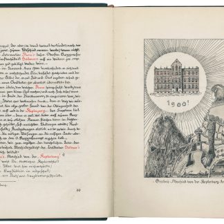
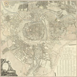
Large-format topographic manuscript, very likely produced as an instructional aid for the use of the Habsburg Empire's military cartographers during the Josephinian Land Survey (1763-1780). The more than 3,500 maps sheets that eventually made up this first comprehensive land survey and mapping project of the Empire are mostly drawn in an entirely comparable style; they were long treated by the monarchy as a strictly classified military and government secret.
The first plate in the present set shows 55 cartographic symbols and representations without any key; the following plates are fictional maps whose scale apparently approximates that commonly used in the Josephinian Survey (ca. 1:28.000) and which show (often densely packed) examples of rivers, lakes, forests, roadways, and settlements of various sizes. The toponyms are mostly unspecific (Wiesenthal, Haag, Furth) or derived from well-known places in the Habsburg Empire (Göfis, Nenzing and Frastanz in Vorarlberg, Ambras Castle in Innsbruck, Krumau in Bohemia, Nikolsburg and Niemschitz in Moravia, Hotzenplotz in Silesia, etc.); there are also a few obviously fictional place names (Freudenort, Juno, Abschied, etc.). Several plates also show off surveying techniques based on trigonometry and simple triangulation, although pressures of time meant that the Josephinian Survey did not in fact use the method widely.
Occasional insignificant spotting, otherwise very well preserved. Includes an additional, uncaptioned sketch in black and red ink (browned and with more severe edge flaws).
For the Josephinian Land Survey see J. Dörflinger, Österreichische Karten des 18. Jahrhunderts (Vienna, 1984), pp. 63-65.
Related
-
Rama tan ma.Wien, 1966.
$2,233.00 -
Der Kepleriania Chronica. Begnadet unter Schirmherrlicher Imprimatur, berichtet, …Wien, 1917.
$1,061.00 -
Grundriss der k. k. Haupt- und Residenzstadt Wien mit ihren Vorstädten …Wien, 1797.
$4,243.00 -

Der Fremde in Wien und der Wiener in der Heimath. Vollständiges Auskunftsbuch …Wien, 1832.
$313.00
