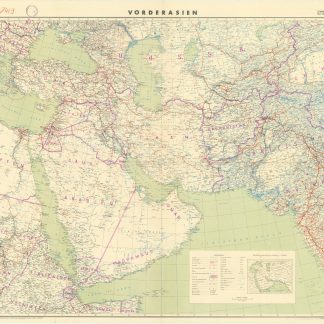
Iran (Persia) and Iraq.
London, George Philip & Son Ltd., 1941.
Colour-printed folding map, 542 x 695 mm. Scale 1:3,500,000. Original printed wrappers.
$558.00
Map of Iran, Iraq and parts of the surrounding countries, including modern Kuwait, Bahrain, Qatar and the UAE (then "Trucial Oman"), published in the series "Philips' Authentic Imperial Maps for Tourists & Travellers". Published in the early years of oil production in the Middle East, the map shows roads and railways, but also caravan routes, submarine cables and oil pipelines.
Provenance
Cancelled ownership of G. R. Parker; stamp of Alfi's Book Shop in Braim, Abadan, to front cover.
Condition
Some small marginal tears, otherwise in fine condition.