
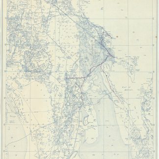
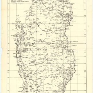
Petroleum facilities in Iraq and Iran
Petroleum Facilities Middle East.
5 black-and-white maps on 1 sheet, 405 x 890 mm. Various scales; index map scale approximately 1:12,000,000 (azimuthal equal area projection). Includes marine shipping distance table.
Five maps on a single sheet, issued by the U.S. Government immediately after the end of World War II. The maps show all relevant petroleum facilities in Iraq and Western Iran, in Egypt, in Southwestern Iran, and in the Kuwait, Saudi Arabia, Bahrain, and Qatar areas, identifying not only international boundaries, capital cities and major towns, principal roads and railways, but also concession boundaries, oilfields, oil refineries, oil pipelines, pumping stations, and marine landing terminals.
A few minute edge flaws, but very well preserved. Extremely rare: OCLC lists a single institutional copy (in the Library of Congress).
OCLC 890759878.
Related
-
Dhahran. Scale 1:500,000.Dhahran, 1954.
€ 5,000.00 -
Qatar. Q/OO. O648.Qatar, 1952.
€ 750.00 -
Jazirat al-'Arab wa-al-manatiq al-mutakhimah la-ha: kharitah tamhidiyah …Dharan, 1950-52 CE = 1369-71 H.
€ 4,500.00 -
Neft ba-mizrah ha-tikhon. Zikaynot, shadot, tzinorot, batei zikuk. (Oil …Tel Aviv, 1957.
€ 5,000.00